The Wingfield Advantage: Certified Weight + Complete Visibility Across Your Entire Mining Operation
Modern mines need both certified weight and complete visibility of all their materials and critical assets. Wingfield is the only company in the United States delivering all of it under one roof.
Critical data gaps
The scale ticket ends at the weighbridge — everything past it is a guess.
Coordination nightmares
Scale vendor, surveyor, drone crew, inspector — four contracts, zero alignment.
Delayed decisions
Delays between vendors slows every production call.
No accountability
When everyone owns a piece, no one owns the outcome.
We offer mining measurement across four critical dimensions:

Truck Scales: The Foundation of Legal-for-Trade Mining Weight
Heavy-duty truck scales, axle scales, rail scales, and portable wheel weighers — engineered for haul truck payloads, calibrated to NIST-traceable accuracy, and installed turnkey by Wingfield’s own concrete and service crews.
- Full-size weighbridge, axle, and portable wheel-weigher configurations
- Turnkey site prep, foundation, installation & calibration in-house
- Solar-powered options for remote pit, quarry & haul road locations
- 24/7/365 service, ISO/IEC 17025 accredited calibration
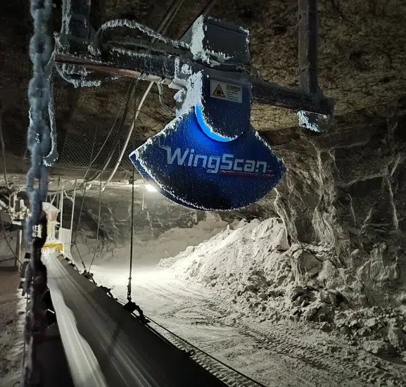
Volumetric Scanning: Where Weight Alone Falls Short
Truck scales tell you weight. But WingScan adds volume, density variance, and load distribution (captured in motion, on belt, truck, or rail, with no platform queues and no calibration drift).
- Instant in-motion measurements — no scale-house bottlenecks
- Military-grade durability for extreme conditions (-40°F to 140°F)
- Maintenance-free operation with no moving parts
- Seamless integration with your existing scale & ticketing software

Intelligent Site Mapping: Beyond Manual Surveys
Capture stockpile volumes, terrain change, and pit conditions from the air — above ground and underground — with autonomous UAV and Hovermap LiDAR systems that cut survey time, exposure, and cost.
- Stockpile volumes — comprehensive, repeatable calculations
- Site monitoring — document conditions and changes over time
- Faster surveys — reduced exposure and crew time on the bench
- Data fusion — integrates with truck scale and ground measurements

Remote Asset Inspection: Beyond Reactive Maintenance
LiDAR-based 4DNA inspection detect wear, structural drift, and failure risk for kilns, refractory, and ball mills.
- Early detection — find problems before they escalate
- Reduced unplanned downtime — prevent costly halts
- Extended lifespan — protect high-value mining assets
- Data-driven scheduling — plan maintenance proactively
Proven Profits Across Mining Operations in North America
- Copper mine: Optimizing truck loads from 85% → 100% saved $0/day (~$1.9M/yr).
- Gold mine: Eliminating leftover material waste saved ~ $0/year.
- Aggregates: Cutting load disputes saved tens of thousands annually.


Solution Finder
Find the right measurement solution for your operation.
Choose the situation that sounds most like your mine, quarry, or processing plant. Each answer points you to the Wingfield mining measurement solution that fits the job. You can also read straight through.
Situation 01
Every weight ticket has to stand up in court.
Recommended: NTEP-certified truck scales | WingScan-T 3D-M volumetric scanner
If your tickets cross a public road, settle a sale, or feed a royalty calculation, the number has to hold up. For that reason, it takes NTEP "Legal-for-Trade" certification, NIST-traceable calibration, and a clear audit trail.
Wingfield is one of the only single-source providers in the Southeast with both certified static scales and certified in-motion volumetric scanning.
- NTEP-certified pit/quarry truck scales, axle scales, rail scales & portable wheel weighers
- WingScan-T 3D-M is the NTEP-approved volumetric scanner for haul trucks (in-motion, legal-for-trade)
- ISO/IEC 17025 accredited calibration with 150,000+ lbs of NIST-traceable test weights
- Turnkey install, foundation, calibration & placed-into-service support
Situation 02
Material flow is outpacing your measurement points.
Recommended: WingScan LiDAR volumetric scanning | right-sized truck, belt, and rail scales
When truck scales, belt scales, or rail scales become the choke point, production slows in tons, minutes, and missed turns. As a result, crews spend more time waiting on measurement and less time moving material. WingScan LiDAR measures material in motion across haul trucks, conveyors, and railcars. At the same time, certified static scales still handle the legal ticket.
- 75% reduction in load processing time vs. static scale + manual ticketing
- 23% fewer haul trips through accurate per-load optimization
- 4 to 7 hour calibration shutdowns eliminated, protecting $3M/hr in revenue (Tacora Resources)
- $330,000/year in prevented losses at Heidelberg Materials with WingScan-B belt scanning
Situation 03
Stockpile counts shouldn't take a week and a guess.
Recommended: UAV LiDAR aerial mapping | Hovermap for indoor & underground
Manual stockpile surveys put surveyors on top of moving piles, take days to process, and arrive too late to influence the monthly close. In many cases, that means the inventory number is already stale by the time finance gets it.UAV LiDAR delivers repeatable volumes in hours. Emesent Hovermap handles the spaces drones can't reach, including domes, silos, underground stopes, and post-blast voids.
- Aerial UAV LiDAR for open pits, stockyards, and reclamation sites with defensible monthly volumes for finance & ESG
- Hovermap SLAM LiDAR for GPS-denied environments including indoor stockpiles, underground drives, and blasted voids
- Volumes that match the way auditors expect inventory to be counted
Situation 04
A surprise shutdown costs more than the asset that failed.
Recommended: 4DNA remote asset inspection
Traditional vibration and temperature sensors miss roughly 77% of the data that predicts mechanical failure. By the time a kiln, ball mill, or refractory lining shows up on a standard monitor, you're already counting downtime in $242,000-per-hour increments. 4DNA reads the full mechanical signature remotely and gives you a 3-week early warning.
- 3-week early warning on kiln, ball mill, crusher, and refractory failures
- Refractory damage alone runs $10K to $15K/hr in lost production
- Remote inspection with no climb, no confined-space entry, and no shutdown to diagnose
- Pairs cleanly with the digital twin and ESG reporting layer in Phase 4
Situation 05
ESG and SOX auditors want one defensible number, not five spreadsheets.
Recommended: NTEP truck scales + WingScan + UAV volumes, unified
Tier-1 mining auditors are asking for tonnage, stockpile, emissions, and asset-condition data that reconciles across systems. When your weight ticket, scanner volume, drone survey, and inspection record trace back to NIST-traceable calibration, the audit is easier to defend.
- ISO/IEC 17025 accredited calibration on every weighing asset
- NIST-traceable test weights (100g to 400,000 lbs) for full-range certification
- Single chain-of-custody from haul truck to ticket to stockpile to financial close
- Defensible documentation that survives ESG, SOX, and royalty review
Situation 06
You're building a 3 to 5 year measurement strategy, not buying a single tool.
Recommended: phased adoption with all four solutions, sequenced
Mining 4.0 is not a single purchase. Mines planning for 2026 are dealing with retiring expertise, tighter ESG and SOX reporting, and fragmented data silos across operations, maintenance, and finance. A phased roadmap turns that into a budget you can defend.
Phase 01
Truck Scales + WingScan lock down legal-for-trade weight and eliminate the scale-house bottleneck. Fastest payback.
Phase 02
UAV Mapping & Stockpile Inventory replace manual surveys with repeatable LiDAR volumes for monthly close.
Phase 03
4DNA Remote Asset Inspection extends visibility into crushers, conveyors, and structural assets to break the unplanned-downtime cycle.
Phase 04
Unified data layer connects ticketing, scanner data, survey volumes, and digital twins into one operational picture that survives retirements and ESG audits.
Wingfield has served mining and industrial operations since 1937. One contract, one service crew, and one accountable point of contact can carry all four phases.
Explore related resources
Go Deeper Into Mining Measurement
The resources below show how NTEP-certified truck scales, WingScan volumetric scanning, and 4DNA remote inspection turn measurement data into fewer haul cycles, defensible tonnage, and the early warnings that prevent unplanned shutdowns.

Legal-for-trade haul trucks
WingScan-T 3D-M for NTEP-Approved Haul Trucks
See how the only NTEP-certified volumetric truck scanner delivers in-motion, legal-for-trade haul-cycle measurement without slowing the scale house down.

Haul-cycle optimization
Mining Load Scanner With 10M+ Trucks and $330K/yr Saved
Explore how in-motion volumetric scanning cut load processing time by 75%, eliminated 23% of haul trips, and protected $3M/hr in revenue at Tacora Resources.

Predictive asset inspection
4DNA Remote Inspection for Kilns, Ball Mills & Refractory
Discover how 4DNA reads the full mechanical signature of kilns, ball mills, and refractory linings to deliver three-week early warnings before unplanned shutdowns.
This is a growing mining measurement library. Lock down legal-for-trade haul tickets, eliminate the scale-house bottleneck with in-motion volumetric scanning, and extend visibility into the assets that drive unplanned downtime.
Mining Measurement Solutions FAQ:
What is mining measurement?
Mining measurement is the work of proving how much material moved, where it went, what it is worth, and whether the equipment behind that movement is still healthy. It covers certified weight, volumetric scanning, stockpile measurement, site mapping, and asset inspection.
For a mine, quarry, or processing plant, good measurement connects the legal ticket with the rest of the operation. The goal is simple. Fewer blind spots, fewer disputes, cleaner inventory, and better decisions.
What is the best way to measure material in a mining operation?
The best method depends on the decision you need to make. Certified truck scales, belt scales, and rail scales are used when weight has to support a sale, royalty, invoice, or compliance record. Volumetric scanning is used when you need faster material flow, load profiles, density insight, or in-motion checks.
Stockpiles usually need UAV mapping, LiDAR, photogrammetry, or mobile scanning. Equipment health needs a different kind of measurement, such as remote inspection and digital twin data. A strong mining measurement plan uses the right tool for each job instead of forcing one tool to answer every question.
When does a mine need a legal-for-trade scale?
A mine needs a legal-for-trade scale when weight affects a commercial transaction. That can include buying, selling, invoicing, royalty reporting, tariff work, custody transfer, or any other record where the measured weight determines value.
In the United States, that usually means an NTEP-certified scale that is installed, placed in service, and calibrated correctly. NTEP certification is not the same as calibration. Certification says the scale model is approved for trade use. Calibration proves the specific scale is reading correctly in the field.
Explore Wingfield truck scales →Does volumetric scanning replace a truck scale?
In most mining operations, volumetric scanning works beside the truck scale. The scale gives certified weight for the legal ticket. The scanner gives volume, load shape, carryback, fill level, and material movement data while the truck keeps moving.
This matters because weight alone does not show whether a truck was underloaded, overloaded, off-center, or carrying material back after dumping. Pairing certified weight with volumetric data gives operations, maintenance, and finance a clearer picture of each load.
Learn more about WingScan load scanning →How does WingScan measure mining loads on trucks, belts, and rail?
WingScan uses LiDAR to capture a 3D profile of material as it moves through the measurement point. For trucks and railcars, the loaded profile is compared with a known empty profile. For conveyors, the scanner reads the material profile over the belt and uses belt movement data to track flow.
The scanner measures volume directly. Weight can be connected through certified scales, belt scales, or bulk density data when the operation needs tonnage. This is useful when a mine needs faster throughput, better load control, or a clearer record of what moved through the site.
How are mining stockpiles measured accurately?
Accurate stockpile measurement starts with a repeatable 3D capture method. Common options include UAV LiDAR, drone photogrammetry, terrestrial laser scanning, mobile scanning, and SLAM-based mapping for indoor or GPS-denied areas.
The survey creates a point cloud or surface model. Volume is calculated against a defined base surface. Tonnage is then estimated from volume and bulk density. Moisture, compaction, pile shape, and the base surface can all change the final number, so the method needs to be documented.
Explore UAV mapping and measurement →How often should stockpiles be measured?
High-volume mines may measure key stockpiles weekly or even more often when material is moving fast. Many operations measure monthly for financial close. Quarterly or annual surveys may be enough for lower-value piles, slower-moving material, or audit checks.
The important part is consistency. Use the same method, the same control process, and the same reporting format as much as possible. That makes month-to-month changes easier to trust.
What causes mining measurement errors?
Common causes include scale drift, missed calibration, poor base surface definition, changing bulk density, moisture changes, incomplete pile coverage, manual ticket entry, and disconnected systems. A small error can become expensive when it repeats across thousands of tons.
The fix is usually process as much as technology. Use NIST-traceable calibration where weight matters. Keep density assumptions current. Capture repeatable survey data. Connect scale tickets, scanner records, and stockpile reports so teams are not reconciling the operation by hand.
How does mining measurement support audit, ESG, and royalty reporting?
Audit-ready mining measurement creates a clear chain of evidence. The weight ticket, scanner record, stockpile survey, and inspection data should point back to a known method, a known date, and a known calibration standard where calibration applies.
This helps when finance, operations, and outside reviewers need to explain the same number. It also reduces the risk of five teams reporting five different versions of tonnage, inventory, or material movement.
Where does remote asset inspection fit into mining measurement?
Material measurement shows what moved. Asset measurement shows whether the equipment that moves and processes that material is still in good condition. Both matter because a perfect material report does not help much if a kiln, crusher, conveyor, or ball mill fails without warning.
Remote inspection tools like 4DNA measure wear, deformation, surface change, and structural risk without putting crews into unnecessary exposure. This gives maintenance teams earlier warning and better records for shutdown planning.
Explore 4DNA remote asset inspection →Can a mine start with one measurement technology?
Yes. Most sites should start with the measurement problem that is costing the most money or creating the most risk. For some operations, that is certified truck scale weight. For others, it is conveyor flow, stockpile inventory, load optimization, or unplanned downtime.
A phased plan usually works best. Start with the highest-value problem, prove the result, then connect the next measurement layer. The long-term goal is one operating picture instead of separate scale, survey, scanner, and inspection records.
Talk to Wingfield about a phased measurement plan →Interested in Wingfield's Mining Measurement Solutions?
Schedule a conversation with a Wingfield specialist!
or call 423-698-0100