Stockpile Yard Example
Point clouds from LiDAR and rendered surfaces used for volume calculation. If the site has tunnels and feeders these can be modeled to provide more exact volume measurements as the stockpiles change over time.

Point clouds from LiDAR and rendered surfaces used for volume calculation. If the site has tunnels and feeders these can be modeled to provide more exact volume measurements as the stockpiles change over time.
A stockpile yard at a port scanned and processed, the rendered surfaces ready for volumetric modeling. Point cloud data can be created from UAV / Drone and combined with LiDAR data.

This UAV can be manually or autonomously flown to map areas that are inaccessible or lack the structural integrity for safe entry. It is commonly used for stopes and voids, failing and older or abandoned working areas, and for basic inspection.

Ensuring large projects such as stripping/overburden projects are captured accurately is extremely important. With access to LiDAR & photogrammetry platforms and post processing abilities for both Wingfield can custom tailor the data capture.

Using a UAV/Drone but don’t have the time to complete post processing? Upload your images and ground control points to Wingfield. We will recommend best practices, validate the uploaded data, and and and ensure post processing is completed accurately.
An example of Pix4D photogrammetry processing. Starting the process from receiving the images from the client we will render and check the data for consistency and issue the reports and deliverables as required by the client.
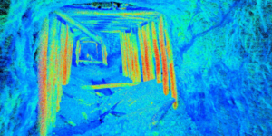
This point cloud data was captured using Autonomous UAV LiDAR to be used for rehabilitation project analysis in a partially collapsed rail tunnel.
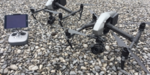
Various types of UAV / Drone systems that can be equipped with photogrammetry or LiDAR are available for a variety of projects. We understand the strengths and weaknesses of each platform and technology, so we can use the right tool for each job we do.
Using our Autonomous UAV/Drone to examine abandoned mine travel-ways allowed our client to understand and mitigate hazard before exposing men and machines. The video-LiDAR displayed critical, otherwise inaccessible data available to decision makers.