Overburden & Stripping Surveys
Visually and quantitively verify contractors reports for overburden removal. Once approved the overall quarry surface can be updated reflecting the new changes.

Visually and quantitively verify contractors reports for overburden removal. Once approved the overall quarry surface can be updated reflecting the new changes.

Create customized data ranges to determine the distance of change and visualize the variance. This can be useful for overburden, reclamation, shotcrete depths, or tracking movement of material.

Material storage enclosure scanned and processed, every material shed or barn presents a unique survey challenge. Custom structural surfaces can be modeled in these areas allowing consistent, repeatable measurements with each measurement.
Point clouds from LiDAR and rendered surfaces used for volume calculation. If the site has tunnels and feeders these can be modeled to provide more exact volume measurements as the stockpiles change over time.
An overlay of the point clouds captured from a LiDAR UAV / Drone is made into strips and overlaid on the final rendered surface. Being able to determine ground surface from the tops of trees and vegetation is critical for volume calculations.
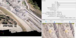
A stockpile yard at a port scanned and processed, the rendered surfaces ready for volumetric modeling. Point cloud data can be created from UAV / Drone and combined with LiDAR data.
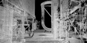
Bringing in new equipment or moving a large piece through a facility. We can help with clearance checks by scanning the structures in the surrounding areas. Data can later be used for additional checks and reference for other projects.
Planning on expanding existing structures, reroute conduits and piping? Have the facility scanned to better plan and prepare for a quick project, silos were scanned at this facility from the ground level and the upper level to ensure proper planning.
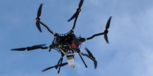
Ensuring large projects such as stripping/overburden projects are captured accurately is extremely important. With access to LiDAR & photogrammetry platforms and post processing abilities for both Wingfield can custom tailor the data capture.
Using a UAV/Drone but don’t have the time to complete post processing? Upload your images and ground control points to Wingfield. We will recommend best practices, validate the uploaded data, and and and ensure post processing is completed accurately.