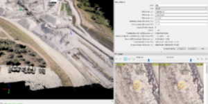
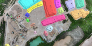
Shed / Barn Stockpile Example

Material storage enclosure scanned and processed, every material shed or barn presents a unique survey challenge. Custom structural surfaces can be modeled in these areas allowing consistent, repeatable measurements with each measurement.

Stockpile Yard Example

Point clouds from LiDAR and rendered surfaces used for volume calculation. If the site has tunnels and feeders these can be modeled to provide more exact volume measurements as the stockpiles change over time.

Stockpile Surface Example

A stockpile yard at a port scanned and processed, the rendered surfaces ready for volumetric modeling. Point cloud data can be created from UAV / Drone and combined with LiDAR data.

UAV/Drone Photogrammetry Post Processing & Upload Service

UAV/Drone Photogrammetry Post Processing & Upload Service

Using a UAV/Drone but don’t have the time to complete post processing? Upload your images and ground control points to Wingfield. We will recommend best practices, validate the uploaded data, and and and ensure post processing is completed accurately.

UAV Post Processing Video Example

An example of Pix4D photogrammetry processing. Starting the process from receiving the images from the client we will render and check the data for consistency and issue the reports and deliverables as required by the client.

Stockpile Inventories

Stockpile Inventories

Inventory is the core of our department and continues to be updated and refined as technology advances. We complete stockpile inventories for various clients with different needs from UAV only, none flight zones, sheds, and underground inventory.