Room and Pillar Scanning
Using static and dynamic LiDAR systems we are able to map, measure, and track room and pillar progress. LiDAR and processing data allows for enhanced visualization of areas of interest and more precise volumetrics.
Using static and dynamic LiDAR systems we are able to map, measure, and track room and pillar progress. LiDAR and processing data allows for enhanced visualization of areas of interest and more precise volumetrics.

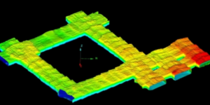
A sample of a room and pillar point cloud and rendered surface used for volumetric calculation, as-built vs design, convergence, mine design updates, and more!
Large underground mines with high roofs or backs can be challenging to check for changes or movement. The LiDAR systems used by Wingfield can scan to a range of 600 meters underground and provide real data that can be compared overtime to track movement.