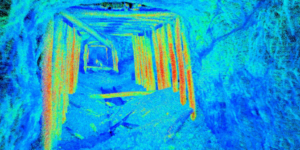
Point Cloud Data of Collapsed Inaccessible Tunnel
This point cloud data was captured using Autonomous UAV LiDAR to be used for rehabilitation project analysis in a partially collapsed rail tunnel.
This point cloud data was captured using Autonomous UAV LiDAR to be used for rehabilitation project analysis in a partially collapsed rail tunnel.
The ability to use various LiDAR and UAV technologies in the field allows us to rapidly capture data in adverse conditions while maintaining timelines for quarry updates or stockpile inventories.

Dynamic LiDAR scanning of the Ford Tri-Motor Aircraft at Liberty Aviation Museum.
Using our Autonomous UAV/Drone to examine abandoned mine travel-ways allowed our client to understand and mitigate hazard before exposing men and machines. The video-LiDAR displayed critical, otherwise inaccessible data available to decision makers.
The premier maintenance-free solution that delivers real-time volume and mass flows on each conveyor belt. Connect, monitor and command each system via secure and intuitive controls on mobile or desktop, or easily connect to a variety of PLC systems.